Township Tuesday
Welcome to Township Tuesday, where each week, we will examine the history of different Lancaster County townships. This week: Manor Township as recorded in the 1875 Historical Atlas of Lancaster County. A few minor edits have been made, mostly for readability, plus adding additional images from sources outside of the 1875 Atlas.
1875 Historical Atlas of Lancaster County
The 1875 Historical Atlas of Lancaster County, Pennsylvania, was compiled by the famous cartographer and atlas maker Major L. H. Everts of Geneva, Illinois. Click here to read more about the Atlas and Everts.
Manor Township
The manor was organized in 1730 and was named after Conestoga Manor, which Jacob Taylor surveyed, Surveyor-General, from 1706 to 1733. The township now contains the original survey of 16,000 acres. The order from the Commissioners of Property touching this survey was as follows:

“These are to authorize and require thee, without any delay, to survey or cause to be surveyed all that tract of land lying between Susquehanna River and Conestoga Creek, from the mouth of said creek, as far up the river as the land already granted to Peter Chartier, and then by a line running from the said river to Conestoga Creek, all of which tract of land for the use and behoof of William Penn, Esquire, Proprietary and Governor-in-Chief of the said Province, his heirs and assigns forever.”
“Given under our hands, March 1, 1717-18.”
The Manor was afterward divided and sold to purchasers and patented. The following were the principal patentees:
Israel Pembertin held 300 acres, the date of his patent October 1, 1723. Messrs. Wrights owned 1500 acres, patented December 13, 1735.

Afterward, they sold it in smaller parcels to John Herr, Andrew Stineman, Daniel Lintner, Jacob Killhaven, Rudy Rep-, Jacob Frantz, Godfrey Klugh, Matthew Oberholtzer, Rudy Herr, Jr., John Killhaven, Christian Hershey, Andrew Kauffman; James Patterson, 107 acres, November 21, 1734; James Logan, 700 acres, July 15, 1737.
Afterward, it was held by George Brenner, Philip Brenner, Christian Stauffer, Casper Souter, Adam Fisher, Valentine Rummel, Lawrence Cliffer, Christian Stake; Michael Baughman, 489; Michael Mayer, 131 acres, both same date, February 20, 1738; Michael Mayer, Sr., 217 acres, October 16, 1737; Abraham Steiner 63 acres, May 3, 1740; John Wistler, 167 acres, July 3, 1741; Jacob Kuntz, 166 acres Anna O. B. K offer, 166; Jacob Hostetter, 475; John Shenk, 197 acres, all patents dated July 30, 1741; Edward Snoout, 113 acres, June 21, 1743; Michael Baughman, 339, May 28, 1752; Abraham Hare, 424, April 22, 1751; Jacob Wistler, 125; Valentine Miller, 140, both May 25, 1756; Martin Funk, 237, December 18, 1758; Jacob Wistler, 202 Jacob Shuck, 185, August 18, 1759; Abraham and John Miller, 89 (the latter was the founder of Millersburgh, now Millersville, and subsequently disposed of his land to Abraham Peters, Sr., and others); Valentine Haith, 29; Robert Beatty, 226, February 1760; Samuel Herr, 247; John Keady, 188; Henry Funk, 150; Jacob Wistler, 173; Ludwich and Frederick Ziegler, 209, all in June 1760; John Witmer, 77; Abraham Miller, 204; Rudolph Herr, 176; Jacob Witmer, 77, all in November 1761; James McMaster, 247, April 1761; John Keagy, 159; Henry Funk, 177; David Hare, 195; John Miller, 150; George Adam Dustier, 112.; John Carroll, 209; Christian Stoner, 244, all in 1761; Michael Kauffman, 116; John Kauffman, 118; Jacob Kauffman, 167; Christian Kauffman, 163; Michael Kauffman, 118; Abraham Steiner, 200; John Wormely, 115; Jacob Whistler, 19; John Kreamer, 184; Bartholomew Butt, 40; John Graff, 136, all in 1762; Philip Ulweiler, 39; Benjamin Miller, 220; David Hare, Jr., 94; Peter Snyder, 86; Henry Atkinson and Adam Bigging, 49; Peter Witmer, 132, all in 1763; John Miller, 60, January 19, 1764; John Newcomer, 109; Joseph Nelson, 109; Jacob Whistler, 178; Mary Wright, 119, dated 1767; John Kendrick, 558; James Pratt, 232, 1768; Henry Buckley, 150, 1769; William Wright, 257, 1770; Ulrich Rehur, 232; John Man-ning, 165, 1772; Jacob Ashleman, 340, 1774; Indian Town, 414; Blue Rock, 800. Fractions of acres are omitted.

Several of the descendants of the above-mentioned original owners of land in Conestoga Manor still reside on their ancestors’ first purchases. Some of the names have become extinct.
Manor possesses many attributes of a fascinating historic character. Here existed the famous Indian town of Conestoga, where the assembled chiefs of the various tribes met the white man to constitute the treaties which ultmate]y led to an amicable settlement of those difficulties that retarded the early settlement of the immediate neighborhood, and the County at large.

Here the great chiefs of the Six Nations gathered to negotiate with the Provincial Governors for the establishment of peace and to complain of the outrages perpetrated by sundry white traders who worked upon the gullibility of the unsophisticated aborigines to their detriment, and the personal aggrandizement of themselves.
Here, too, the first massacre of the Conestoga Indians took place, the horror of which was without parallel in the annals of our local history, and which was the harbinger of many atrocities and much bloodshed. But the days of their glory and their possession have departed, and not a vestige of the Indian characteristic remains to designate the place where they once resided. The Indian wigwam constituted the grandest architectural monuments of the County less than a century and three-quarters ago.
The place still bears a name significant of its early associations—Indian Town. Here the analogy rests. Click here to read more about the massacre of the Conestoga Indians.

Millersville
The principal town in Manor Township is Millersville, formerly known as Millersburgh, and later as Millerstown. It was laid out by John Miller in 1768. The original patent was given by Thomas Penn, Esquire, in 1757 and constituted a part of old Conestoga Manor.

The town was laid out in five-acre lots at first, some of which were purchased by one Paul Houseman, who sold two of them to Mr. Abraham Peters, father of the gentleman of that name who was born in the place in 1791, and has ever since been a resident of it. The original deed is now in possession of that gentleman. It bears the date 1764, referring, however, to October 16, 1738. At this time, the tract was purchased by one Michael Mayer, who sold to Miller, and he to Houseman, and he to Peters, in whose family the lots—with two additional ones of five acres each, or a parcel containing ten acres, bought by Abraham Peters, Sr., of one Jacob Sinn—remain. As early as 1764, Houseman kept a tavern here on the present site of the ” Black Horse,” erected by A. Peters, Jr., in 1825. There was a store here as early as 1763 or 1770. but the only one of which any record exists was that of Philip Shissler, built about 1789.

A post-office was established here in 1820, the commission coming to Mr. Peters through ex-President Buchanan.
John Lintner made an addition to the town in 1810; otherwise, the boundaries are the same as at first laid out. There are two buildings, yet standing-that were erected previous to the Revolution. One is a tenement house, now owned by Henry Kintner, and occupied by a German farmer. Jacob Sinn built it. The other stands nearly opposite, on the Blue Rock road.
The town has made considerable progress of late and is now the largest town not incorporated in the County.

Here is the State Normal School for the Second School District of Pennsylvania, which sprang from a small academy established at Millersville in 1854. In the fall of 1855, the Lancaster County Normal School was opened in this building. After the passage of the Normal School law in 1857, a large new building was erected, which by additions, has assumed the present commodious proportions, making it one of the finest school buildings in the State. It is under the management of Professor Edward Brooks, a successful and highly competent educator.
Millersville has six general stores, a drug store, a hardware store, three hotels, three coach manufactories, two lumber and coal yards, several cigar manufactories, and a fair representation of the usual businesses of a flourishing town. There are four churches, one each of the Lutheran, Reformed, Methodist Episcopal, and United Brethren denominations. The first church edifice erected was in 1843 and was used jointly by the Lutheran, Reformed, and Mennonite congregations. The Methodists had a church organization here long before this, as did the Lutheran and Reformed Churches, but no sacred edifices were erected.
In June 1874, the street railway from Lancaster to Millersville was constructed at the cost of $40,000 and was one of the chief improvements of the place. The cars make five trips daily, to and from the city. Click here to read more about Lancaster County’s trolley service.

Millersville’s population in 1870 was 1,180; it is now estimated at 1,400, which is not at all an exaggerated estimate. The town is peculiarly healthful and beautifully situated. Being within easy distance of Lancaster (about three miles), it enjoys all the advantages of a fine suburban town.
Washington Borough
Washington Borough was formed by the consolidation of the two towns of Washington and Charleston and was legally incorporated by an Act of Assembly, approved April 13, 1827. Washington village was laid out before 1800 by Jacob Tritt; Charlestown contemporaneously, by a Mr. Charles. It is situated on the Susquehanna, about three miles south of Columbia.
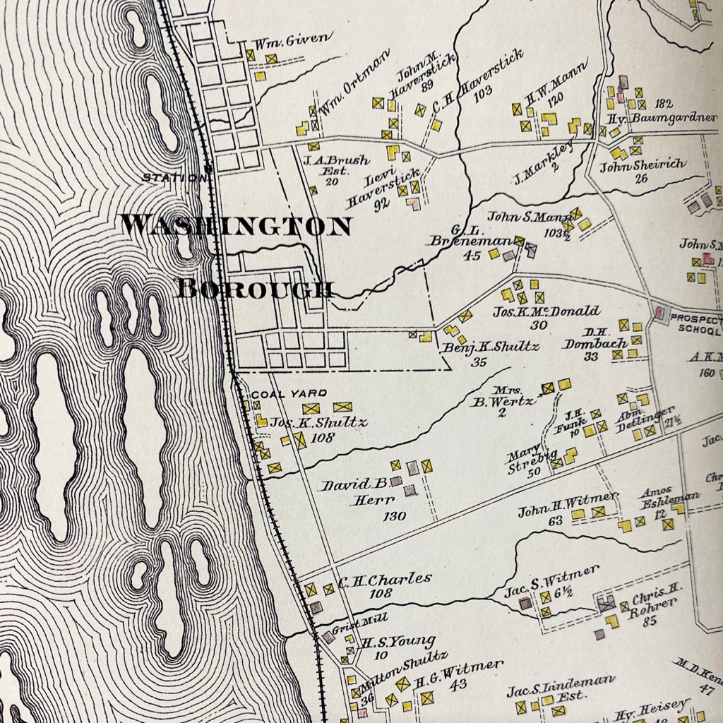
Years ago, it was one of the liveliest business towns in the County, but by some means, it was allowed to deteriorate and has but recently began to improve. The principal business features of the place are fish and lumber. The inhabitants are generally an industrious class of citizens, and many of them, possessing a thorough knowledge of the river, make a living by piloting rafts down the stream. Washington contains the usual number of stores, manufactories, and other places of business.

In 1870, its population was 673. It is now estimated at 900. As returned by the assessor in 1874, the number of taxables was 200; the assessed value of real and personal property, $159,219. The Columbia and Port Deposit Railroad runs through the town, and when completed, a depot will be established there. This will add an impetus to its future growth and prosperity.
Manor Township is in every respect the best and richest township in the County. Its area is 25,700 acres; the soil is a rich limestone, surface rolling and hilly. Chief productions, wheat, corn, and oats, though tobacco has become the staple product. It contains fourteen grist and four sawmills, three distilleries, eight hotels, seven stores, and twenty-one common schools. There are five post-offices, viz., Millersville, Cresswell, Highville, Manorville (recently established, Mrs. Breneman, Postmaster), and Manor (Washington Borough).

Among the most prominent farmers are C. B. Herr, Jacob Seitz, Benjamin Landis, Henry C., and Jacob C. Kready, Amos B. Shuman, Charles, and Abraham Bauman, David Herr, Abraham Peters, Rudolph Gamber, John Doner, Christian B., and Jacob B. Brubaker, and many others.
The population of the township in 1870 was 4,371 (the largest of any township in the County); of which 4,251 were native-born, and 120 foreign; 4,350 white, and 21 colored. As returned by the assessor in 1874, the number of taxables was 1,210; assessed value of real and personal property, $4,671,624, both of the latter items being largely in excess of those returned in any other township.

Click here to see more entries from the 1875 Historical Atlas of Lancaster County.

Adventure Awaits!
Never miss a new article by signing up for email updates below. Be sure to follow Uncharted Lancaster on Facebook or Instagram for additional exclusive content.
Shop
Purchase a beautiful reproduction map of Manor Township and other related areas.
-
 1875 maps of Washington Boro and Bainbridge, Lancaster County, PA$27.99
 -
 1875 map of Manor Township, Lancaster County, PA$27.99
 -
 1894 Map of Millersville, Lancaster County, PennsylvaniaPrice range: $29.99 through $34.99
 -
 1899 Map of Manor Township, Lancaster County, PAPrice range: $29.99 through $34.99
 -
 1864 Map of Manor Township, Lancaster County, PAPrice range: $24.99 through $25.99
 -
 1864 Map of Borough of Washington and Borough of Columbia, Lancaster County, PAPrice range: $22.99 through $24.99
Discover more from Uncharted Lancaster
Subscribe to get the latest posts sent to your email.
I am a descendant of S.B. Urban listed on the last map shown of Washington Boro, as well as M.D. Kendig #47 on the bottom right corner of the first map of Washington Boro. M.D. is Martin Deitrich Kendig, son of Martin Kendig (1799-1846) of Creswell. I am trying to find his parent but have no luck given the prevalence of the name. Any leads would be appreciated.