If you enjoy old maps the way I do, then you will love this one from 1821, highlighting Lancaster County and its various townships, waterways, rivers, turnpikes, roads, mill sites with owner names, furnaces, and churches.
Prolific cartographer and engraver William Wagner created the map. Today, few people are aware of Wagner’s handiwork; however, for most of the 1800s, everyone in York County knew his name.
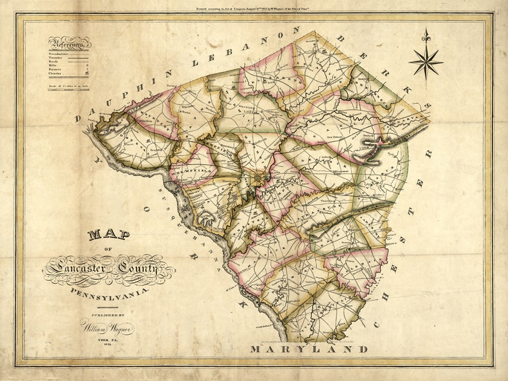
Wagner’s map is historically significant. It is the first official document to show Lancaster County’s modern iconic shape. Since its creation on May 10, 1729, Lancaster’s boundaries have changed several times over the decades, and it wasn’t until 1813 that it finally transformed into the diamond silhouette we recognize today.
A Brief History About William Wagner
Wagner had a considerably lengthy CV. First and foremost, he was an artist and engraver. However, his other vocations included banker, druggist, town office holder including Chief Burgess of York, postmaster, and probably York County’s first photographer.
Wagner was born in 1800, one of eight children of German Reformed minister Daniel Wagner and the former Anna Marie Reitzel. Although his father died when he was ten, William grew up among thriving older siblings.
By the young age of 21, Wagner had become an accomplished engraver when he and partner Daniel Small published the stunning and still-useful 1821 Map of York & Adams Counties. Hand-colored copies sold for $1.5, while plain ones were only a dollar.


The document has beautiful ornamental details, including Lady Liberty in the upper right-hand corner cradling a tablet with the inscription, “Dedicated to the citizens of York & Adams Counties .”
Wagner’s engravings were not simply limited to maps. He also created a series of banknotes for the York Bank, where his brother Samuel was also a cashier. The five-dollar note depicted the streetscape of the York Bank building on West Market Street. The ten-dollar note highlights a view of York from the north, showing a town framed by the Codorus Creek.

He also created seals for organizations, businesses, and governmental bodies all over the country. Some of his clients included the Commercial Bank of Florida, Pennsylvania Surveyor General’s Office, the Circuit Court of Appomattox County, Virginia, and the Circuit Court, Greenbrier County, Virginia. Shown below is the Circuit Court of Greenbrier’s seal. It has a unique story. A West Virginia resident found it while plowing his garden.


Wagner was also a busy printer. He produced marriage certificates engraved with an intricate oval wreath of flowers and clasped hands and heart under the motto “What God Hath Joined Together Let No Man Put Asunder.”
Perhaps Wagner’s most significant gift to York County is his book of 38 watercolors that highlights various scenes of York in 1830. These paintings give a window into the past showing how the York area looked almost 200 years ago. The York County Heritage Trust holds the originals. Click here to see Wagner’s 1830 paintings matched with their modern Google Street Views counterparts.
I have attempted to match several of Wagner’s 1830 paintings with its modern Google Street Views counterpart. Those Then & Now comparisons can be found below.


YCHT has a large file on Wagner that includes original seals and casts of seals, plates for engraving money and advertisements, and his 1830 book of watercolors.
Purchase a Print of Wagner’s 1821 Maps
Here’s your chance to own some of Wagner’s work. I am currently selling 18″ x 24″ matte prints of Wagner’s Lancaster County map as well as 18″ x 24″ and 24″x 36″ matte prints of his York & Adams Counties map.
-
 1821 Map of York & Adams Counties PosterPrice range: $29.99 through $34.99
 -
 William Wagner’s 1821 Map of Lancaster CountyPrice range: $24.99 through $44.99
Here are two close-ups: one featuring Lancaster and the other of the Welsh Mountains. Spelling was more fluid back then (and still now on Facebook, it would seem).


I have also edited the original Library of Congress image to improve the map’s appearance by removing notes written in pencil, some tears, some fold lines. Before & After images are immediately below.


Resources
- William Wagner–York’s Renaissance Man
- York’s First Photographer–William Wagner, 1845
- William Wagner, Lewis Miller made York, Pa. ‘one of the most highly depicted communities in the early nineteenth century United States’
- William Wagner seal dug up in West Virginia
- Views in the Borough of York and Vicinity Taken in the Year 1830

Discover more from Uncharted Lancaster
Subscribe to get the latest posts sent to your email.
This is a wonderful look into William Wagner’s life as an artist! Thank you so much!