With Lancaster Conservancy’s annual Water Week festivities beginning today, here are some fun facts about Lancaster County’s most significant body of water: the Susquehanna River.
Sic Parvis Magna – Greatness, from Small Beginnings
The Susquehanna is the longest river on the East Coast of the United States. The river begins life as an unassuming 50-foot wide creek at the Ostego Lake near Cooperstown, New York. It eventually empties into the Chesapeake Bay at Havre de Grace, Maryland, having swelled in spots to wider than a mile. The river and its hundreds of tributaries drain 27,510 square miles, and, at the end of this 444-mile journey, it pumps 18 million gallons of water into Chesapeake per minute.

For most of the Susquehanna’s 444 miles, the river meanders along lazily, falling two to three feet per mile; however, as the river enters Lancaster County, the steepness increases. Gradually at first and then dramatically. The river drops 208 feet in its final 27 miles, or 7.7 feet per mile. That’s three to four times that of the upper part of the river. That’s why we have four major hydroelectric dams on the Lower Susquehanna.
Ancient River
Geologically, the Susquehanna River is one of the oldest major river systems in the world. If it isn’t the oldest, it is definitely in the top five. It dates back to the Paleozoic Era (543 to 248 million years ago). There is evidence that the flow of the ancient Susquehanna was established early enough to predate the Appalachian mountains’ formation over 300 million years ago.
As a point of reference, the Nile—one of those cradle of civilization rivers—is only 30 million years old.

Etymology
“Susquehanna” may come from the Lenape (Delaware) word siskëwahane meaning “Muddy River.” Alternatively, it may come from the Lenape term Sisa’we’hak’hanna, which means “Oyster River.” Oyster beds were widespread in the bay near the mouth of the river, which the Lenape farmed. A third account translates “Susquehanna” from the Susquehannock language as “the stream that falls toward the south” or “long-crooked-river.”
Lancaster County “Owns” the River
When you look at a map where a body of water separates two properties, such as a county, state, or even a township, the boundary line is typically split down the middle. Here are three examples.


That’s not the case with the Susquehanna River between Lancaster and York County. Beginning on May 10, 1729, Lancaster County encompassed the land on both sides of the river of what is today Cumberland, Berks, Dauphin, and York Counties. When York County was created on August 19, 1749, Lancaster kept all of the Susquehanna River for itself.

A new Philadelphia on the Banks of the Susquehanna
William Penn had a bold plan to create a “New Philadelphia” along the banks of the Susquehanna. This rival city would have been situated on a 3,000-acre site in Manor Township just north of Turkey Hill. The city would have been ideally placed at the end of present-day Blue Rock Road, which at the time was considered the gateway to the west.


A city of this magnitude would need a significant harbor to supply it. Penn planned to widen the Conestoga River at Safe Harbor to literally create a “safe harbor” for ships coming up the Susquehanna from the Chesapeake Bay.
A similar plan had worked in Philadelphia with the Delaware River, so why not for this new city and the Susquehanna River? Just look at the map below. Instead of through the Delaware Bay and up the Delaware River to Philadelphia, Penn’s New Philadelphia plan had ships traveling through the Chesapeake and up the Susquehanna to Safe Harbor.

However, what Penn did not know about the Susquehanna was this final fun fact.
Commercially Unnagivatable
The mighty river is the longest commercially unnavigable river in the United States. Captain John Smith learned this first hand in 1608 when he ascended the Susquehanna until stopped by rocks. On his map, he calls this point “Smyths Fales” (Smith Falls), marking it by a +, which he explains as meaning “hath bin discovered what beyond is by relation.”

Adventure Awaits!
Never miss a new article by signing up for email updates below. Be sure to follow Uncharted Lancaster on Facebook or Instagram for exclusive content.
Learn More
Was Lancaster County formed to rid Chester of its “thieves, vagabonds, and ill people”?

On May 10, 1729, Lancaster County was erected after being carved out of a large portion of Chester County. Legend has it that beginning in 1728, residents living in the backwoods of Chester County began to complain that “thieves, vagabonds, and ill people” had infested the rural areas of what is now Lancaster County. They petitioned William Penn’s son for the creation of a new county to jettison these undesirable residents. Click here to read more.
-
 1875 map of Lancaster County, PAPrice range: $24.99 through $44.99
Port of Lancaster and the Curious Etymology of Safe Harbor’s Name
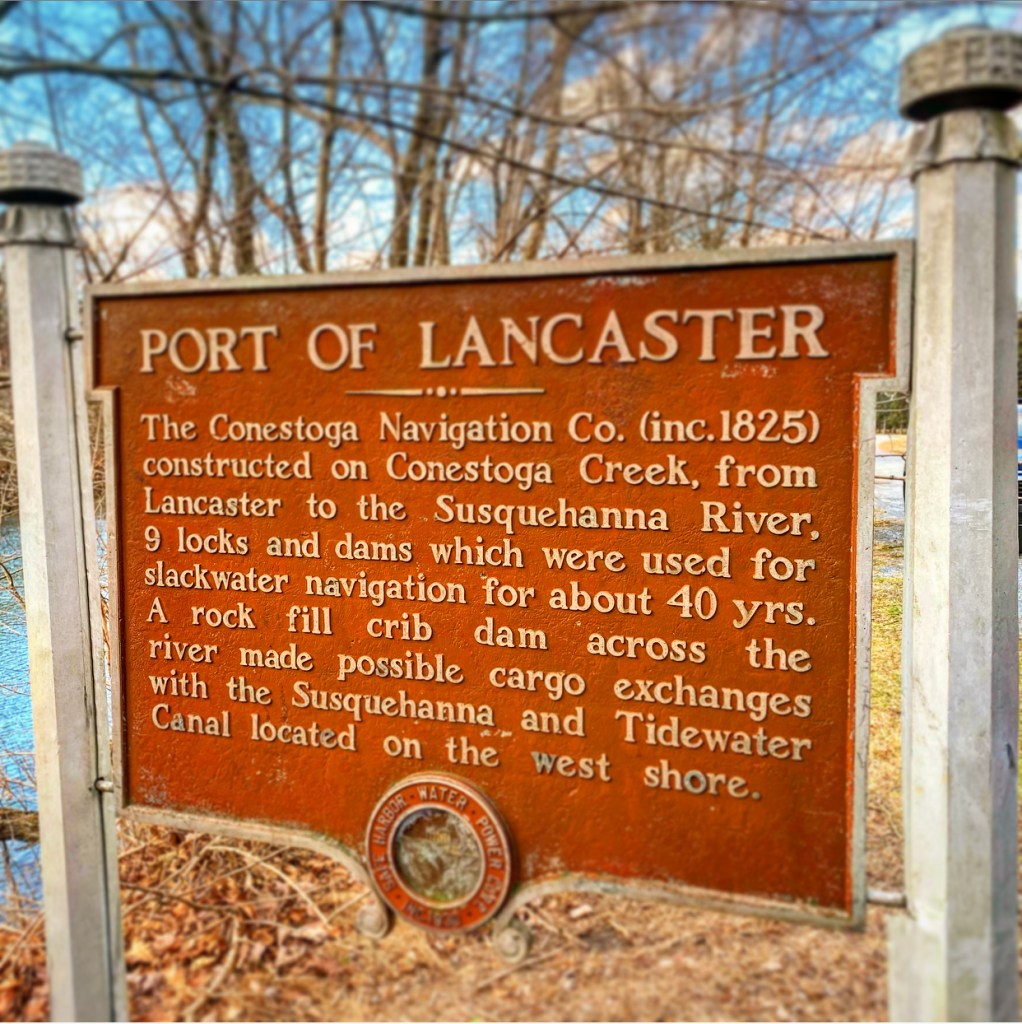
How did the area where the Conestoga empties into the Susquehanna River become known as Safe Harbor? The history of the town and the eventual dam’s name is ambiguous. One theory suggests that river crews knew the deepwater there was a “safe harbor” before facing the treacherous rapids further south. However, there’s a second, much more interesting theory, and it centers around making the area an actual harbor. Click here to read more.
Discover more from Uncharted Lancaster
Subscribe to get the latest posts sent to your email.