As part of Lancaster Conservancy’s annual Water Week festivities, I led a Falmouth Northwest River Trail History Hike on June 4, 2023. There we explored a portion of the historic Pennsylvania Main Line Canal route between the Falmouth Boat Launch (Collins Lock) and Prescot Road (Bainbridge Lock), visited Lancaster Conservancy’s Falmouth Forest Garden at Conoy Wetlands Nature Preserve, and for those looking to super-size their adventure, traversed the unique geologic features of the nearby 750,000 years old Conewago Falls potholes.


Here are some of the information I shared during the canal portion of the hike.
‘One of the Most Important Rivers in the State‘
According to Ellis & Evans’ 1883 History of Lancaster County, Pennsylvania, “The Susquehanna is one of the largest and most important rivers in the State.” Unfortunately, at 444 miles long, it is also the longest commercially unnavigable river in the United States. Captain John Smith had a vague idea of the river’s obstacles when he attempted to ascend the Susquehanna in 1608 while mapping the Chesapeake Bay but was soon stopped by rocky waters.
On his famous Map of Virginia, he called this spot “Smyths Fales” [Smith Falls], marking it with an ✖️, which he explained as meaning “hath bin discovered what beyond is by relation.”

Trappers returning from the western frontier of what would eventually become Lancaster County in 1729 spoke of rich soil, timber-filled forests, and abundant wildlife. Europeans desired to push into this bountiful land that many saw as “free” to claim; however, one major problem kept the potential settlers from truly possessing the land—transportation. How could they get there with their belongings? By what means could they get their produce to the eastern markets?


The dangerous nature of the Susquehanna was soon seen as a “great obstruction and bar to the wealth and population of our Western country” as reported by a committee appointed to survey the river in the late 1700s. To remedy the situation, the Pennsylvania Assembly declared the Susquehanna a public waterway in 1771 and began taking steps to improve it. The most problematic area was the Conewago Falls, sometimes called the “Susquehanna Falls,” where a hazardous 19-foot drop over a quarter-mile stretch occurred.
.
During this time, except during the spring freshets, all rafts and boats had to be unloaded before reaching the Conewago Falls. Wagons then carried the freight to York, Baltimore, Carlisle, and points west. Because of these challenges, the first canal ever built in Pennsylvania (and one of the nation’s first) was opened on the west bank of Conewago Falls, close to where the York Haven dam stands today.
Definition
Freshets: The flood of a river from heavy rain or melted snow.

In 1790, it was decided that it would be too expensive to build a full canal along the western bank of the Susquehanna because the hills ran to the edge of the river. Therefore, a one-mile canal was built around the falls at York Haven on the eastern shore. It had two locks at its southern end, each 12 feet wide and 80 feet long, capable of lowering a raft or flat-bottom boat a total of 20 feet.
Fun Fact: Creeks and streams that crossed the canal’s path were typically carried beneath the canal bed through a culvert to prevent sediment from the creek from filling the canal.
The General Assembly allocated $5,250 for the canal project but spent a total of $102,000 (or $2,436,458.74 in 2023 money). As such, the original plan of making the canal free for all boats was abandoned, and the legislature authorized the collection of a $.50 per boat toll.
On November 27, 1797, the canal officially opened. A General Kreider from Juniata County soon passed through the canal with a load of flour and landed safely in Baltimore three days later. As news spread, towns all over the commonwealth called for constructing more canals. The state legislature answered!

In February 1805, the Assembly authorized a lottery to raise $20,000 dollars to improve the Susquehanna and its branches, with $5,500 spent to improve the river between Columbia and Swatara.
Two decades later, in 1826, the state created a “Board of Canal Commissioners” and appropriated $300,000 to construct canals extending from the Juniata River (Clark’s Ferry) to Columbia. This stretch of the Pennsylvania Canal became known as the “central division.” On December 17, 1830, the section of the canal extending from Columbia to Chiques Creek opened.
The expanded and improved canal was 40 feet wide at the top, 28 feet at the bottom, and four feet deep. Locks between Columbia and Duncan’s Island (near the mouth of the Juniata River) were 90 feet by 17 feet and typically faced with stone.


Other nearby canals, including the Conestoga Navigation Company (incorporated in 1825) and the Susquehanna and Tidewater Canal (incorporated in 1835), were built and opened to the public.
At the height of canal operations on the Susquehanna, the section bypassing the Conewago Falls saw more than 1,500 hundred arks, rafts, and other watercraft pass through the canal during one spring freshet in 1838.
Definitions
Raft: A temporary boat often made of logs and lumber destined for the sawmill. Typically carried little more than the men required to handle her.
Ark: A temporary boat used for river transport and carried everything imaginable, such as grain, livestock, coal, iron, brick, shingles, etc…
Packet Boat: Medium-sized boats designed for domestic mail, passenger, and freight transportation on rivers and canals, some of them steam-driven. They were used extensively during the 18th and 19th centuries and featured regularly scheduled service.


Most canals along the Susquehanna ceased operation in the early 1900s, replaced by the more reliable railroad.
Resources
- Canals along the Lower Susquehanna
- History of Lancaster County, Pennsylvania
- LancasterHistory: canal photos
Adventure Awaits!
Never miss a new article by signing up for email updates below. Be sure to follow Uncharted Lancaster on Facebook or Instagram for exclusive content.

Learn More
Water Week: Susquehanna River Fun Facts

With Lancaster Conservancy’s annual Water Week festivities beginning today, here are some fun facts about Lancaster County’s greatest body of water: the Susquehanna River. Click the link to read all six!
-
 1864 Map of Borough of Washington and Borough of Columbia, Lancaster County, PAPrice range: $22.99 through $24.99
Port of Lancaster and the Curious Etymology of Safe Harbor’s Name
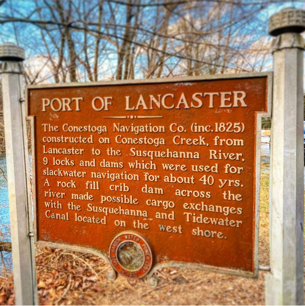
How did the area where the Conestoga empties into the Susquehanna River become known as Safe Harbor? The history of the town and the eventual dam’s name is ambiguous. One theory suggests that river crews knew the deepwater there was a “safe harbor” before facing the treacherous rapids further south. However, there’s a second, much more interesting theory, and it centers around making the area an actual harbor. Click here to read more.

Discover more from Uncharted Lancaster
Subscribe to get the latest posts sent to your email.