
Download the map of Wind Cave.
Finding Wind Cave
Most websites have you park in the town of Pequea near the marina to start your hike, but that more than doubles the trek. You can park much closer to the cave near the corner of Bridge Valley Road and Ridge Drive. Click here for directions. Just keep an eye out for no parking signs being sure to respect other people’s property and driveways.

Once parked, start down the access road that heads toward the railroad.

If you are looking to supersize your adventure with a side quest, check out this hidden culvert beneath Bridge Valley Road close to where you parked. It’s just a few feet off the Conestoga Trail. I usually wait until after I’ve explored the cave to traverse the culvert so I don’t have wet shoes the whole time. Click here for more information on finding the culvert.

You won’t be on the access road for long, so watch for the trail leading up the hill on the left. You’ll have to cross a small stream, which is quickly done with a running jump.

The trail is well-traveled and clearly marked with spray-painted orange tags on the trees.

After a short .3 mile walk, you will arrive at the Wind Cave.
Northern Corridor
Wind Cave has two entrances. Each one accesses different parallel corridors inside the cave complex. The two corridors are connected by a single passageway that runs perpendicular between them. The main entrance is easily accessible with its eight-foot-tall and three-foot-wide opening.

As you enter, the floor slowly descends until the flat ceiling is 15 to 25 feet high above you. As you travel this relatively straight corridor, a few large fallen boulders will block your path, requiring some minor parkour skills to pass. Eventually, somewhere between 175 to 200 feet—depending on one’s girth—the passageway will become too narrow to advance further despite a ceiling height of 20 feet.

Southern Corridor
The other parallel and much larger southern corridor can be reached in one of two ways. First, the easier of the two. Using the main entrance, travel about 75 feet into the cave until you find a small passageway that makes an abrupt right-angle turn. This connecting passage is about 50 feet long and three feet wide with a five-foot ceiling. Shortly after entering the passageway, it drops down to a lower level, eventually joining the corridor that runs parallel to the first.

The other way to access this larger corridor is to use the second and much smaller entrance, which can be found outside about 75 feet to the right of the main entrance. Using this entrance will require some crawling and squeezing.

However, most people use this entrance to exit the cave as it seems easier to squeeze out than in.

Dynamite in Wind Cave
The southern corridor has multiple passageways, some of which may remain hidden and unexplored. It was in this part of the cave that B. Hivner, in 1956, used some dynamite to blast open a side passage (highlighted in yellow below), revealing another 100 feet of cave. This new section consisted of a high and narrow canyon-like passageway and lower stoopways similar to other parts of the cave. Because of its difficulty in entering, this section of the cave is rarely visited.
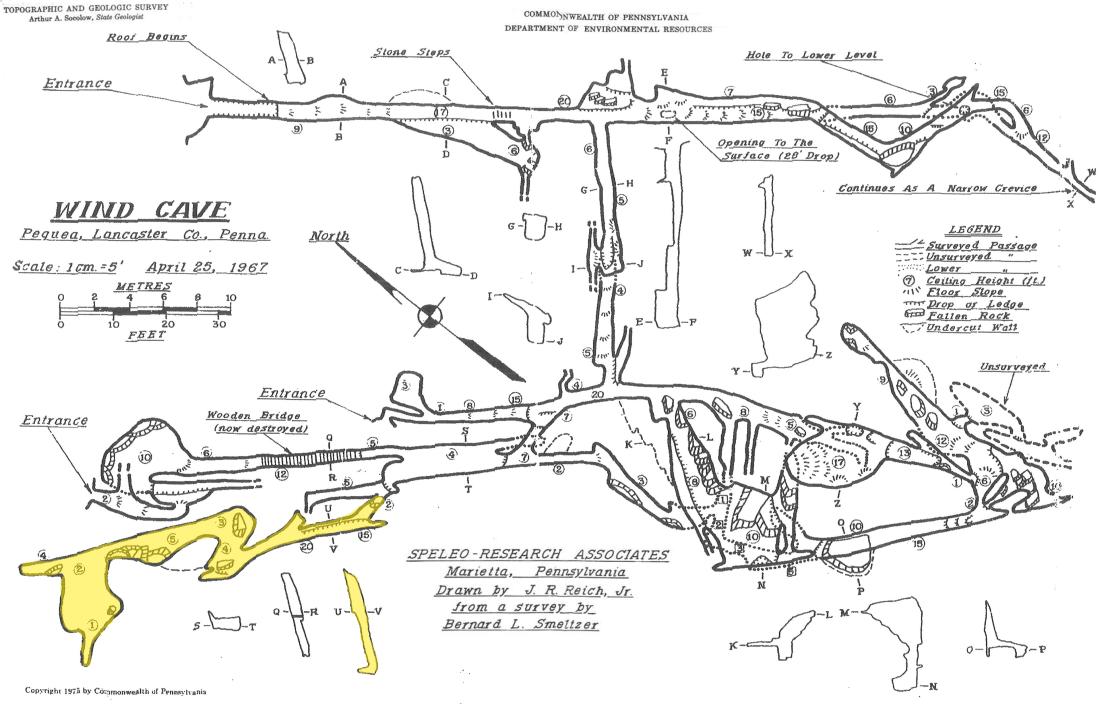
Then, just six years later, in August 1962, another room (highlighted in orange below) was discovered on this side of the cave. It can be entered from the north through a breakdown or from the south through a tight crawlway. The room is 12 feet wide, 20 feet long, and up to 17 feet high. A canyon-like passage on the south side connects to the previously mentioned crawlway.

Unexplored Chambers?
George F. Jackson, in the 1974 publication Caves of southeastern Pennsylvania, believes “the possibilities for finding more cave are good if one wants to invest the time necessary to enlarge the narrow crevices.” Pickaxe anyone?

Learn More
If you want to learn more about Wind Cave, click here.