A recent expedition along the Conestoga River had Benton Webber and I exploring the feasibility of a Conestoga Greenway trail extension between South Duke Street and Engleside.

As we surveyed the route, we came across a very odd stone platform located in the back corner of Riverview Cemetery.
Webber’s first thought was it was a foundation of one of the ice houses that use to be found in this general area.

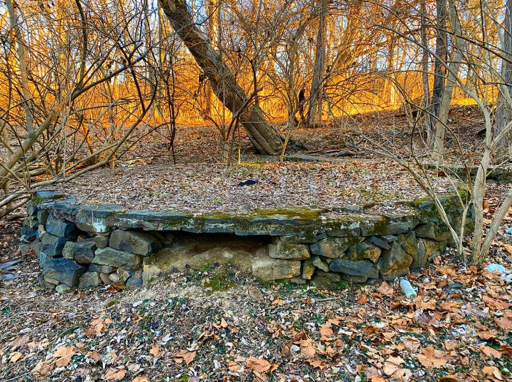
Upon closer inspection, we discovered that the structure was, in fact, circular in shape, which mostly voided the ice house theory. Here’s how Webber described. “It’s roughly level and protruding above ground by nearly two feet with a small and long retaining wall upslope of the circular section and parallel to the river.”

Being on the edge of Riverview Cemetery, I wondered if the structure was once a gazebo or pavilion for the cemetery that time has since erased. The Google map below marks the exact location of the foundation.
The long retaining wall uphill from the river is shown below. The circular platform is visible in the upper left-hand corner.

Here’s a brief video clip by Webber panning over the structure.
What do you think?
What do you think this stone foundation’s original purpose was? I would love to know your thoughts. Comment below.
Resources
- Image 65 of Sanborn Fire Insurance Map from Lancaster, Lancaster County, Pennsylvania.
- Image 1 of Sanborn Fire Insurance Map from Lancaster, Lancaster County, Pennsylvania.
Discover more from Uncharted Lancaster
Subscribe to get the latest posts sent to your email.
its also known as the Riverview Burial Park. Its listed on find a grave, as cemetery #1542536, it has 12,398 graves entered.
The platform appears to be connected to the retaining wall at the same level, as if it was an entrance, or meant to be a part of the wall structure? My money would be on something ornamental connected to the cemetery, whether a small gazebo or a decorative column or monument. Looking forward to hearing anyone else’s knowledge!
You can find an 1892 view of this area here: https://digital.fandm.edu/object/scholars-square965 (page 70 of 90)
Thanks for sharing this!
Could it have been a grist mill? What an interesting article!
I’ve been reading about an area close by there, there’s a plaque designating where Robert Fulton in 1779 conducted his first experiment with paddle wheels for the propulsion of boats. When the plaque was designated in 1972, Agnes the storm & flood destroyed the new garden two weeks later, but the plaque remained. The gardens were re-built but only Hemlocks and the plaque are there today.
That’s very interesting. I’ll look into that.
A cistern?
A cistern related to an icehouse? Watch this video closely: https://digg.com/video/how-did-icehouses-work
It’s a cannon platform.
Could have been a barn and grainery.
Wasn’t aware of the round structure. My grandparents and great grandparents are buried near the old sunken garden. We loved playing in the remains of that as kids in the 50’s. I still visit that cemetery and will check out the other structure.
Whoa. “Looking NE from East Orange.” My house on E Orange wasn’t even built for another 7 years.
I have only questions at this point in time. Might these be the foundations of the log grist mill that Theodorus Eby and his sons built on his 300-acre tract of land along the Conestoga Creek circa 1717? Might the round feature have supported a horizontal grinding wheel? Might the square hole in the center of this circular feature have supported the vertical axle that turned the upper portion of the horizontal grindstone?
This area was once called the “Head of the Navigation” for the Conestoga “creek”. There were locks just downstream of this area and all the way to the Susquehanna. The “creek” level was higher back when the Conestoga was used for transportation, this structure appears to be at the high water mark from that era. I’d imagine that was used for funeral ceremonies where the deceased was presented on that round platform with water up to the wall. Kind’a weird but whatever. FYI, that entire side of the river was posted last fall and is now “No Trespassing”.
The stone work appears “casual” in style, not what is typically seen in industrial/railroad/public works facilities. The low walls do not appear to have a significant function in leveling the site as a retaining wall would. The alignment of the walls and their dimensions do not suggest a foundation for a structure, their function seems to be to define an area for some activity. Based on these observations and the surrounding known land uses, I am thinking it is some sort of memorial or casual outdoor facility. That’s my two cents.
What a puzzler? I’m very eager to know what it is.