Background
My friend and contributing writer here at Uncharted Lancaster, Ben Webber, has been interested in accessing the Safe Harbor Water Power Corp archives. One of his passions is the Conestoga River history, and he’s been searching for an ancient map of the winding river that is rumored to exist in their archives.
As it turned out, I have a contact there, and after a few months of discussions, we were granted access. In addition to helping Ben look for these old river maps, I had the goal of scanning as many of their images, maps, and blueprints that might be of interest and eventually making them available to the public. During our initial visit, we spent four hours going through several boxes containing hundreds of files. Here are three images that caught our attention.
Native American Remains & Artifacts
The following three photos found in the Safe Harbor archives were likely taken by Donald Cadzow or a fellow team member during their 1930-1932 field survey of areas that would be affected by the rising waters due to the Holtwood and Safe Harbor hydroelectric dams. Cadzow’s survey recorded a fascinating variety of petroglyphs and Native American sites in the Safe Harbor area, many of which are now underwater. His findings are recorded in his Safe Harbor Report No. 1 and Safe Harbor Report No. 2.


Please note that the captions are written exactly as found on the photographs.
The first photograph, labeled as #501, says, “#501: Indian graves found near Safe Harbor.” It was taken on July 30, 1930.

In Cadzow’s forward to Safe Harbor Report No. 2., he wrote this about his work.
Archaeological research carried on by the Pennsylvania Historical Commission along the lower Susquehanna River in 1931 and 1932 was primarily to establish an occupation contemporary with the petroglyphs found in the vicinity of Safe Harbor in 1931 and described in Safe Harbor Report No. 1 of this publication series. In this search, evidence of a much later aboriginal tenure of the region was discovered, and several archaeological sites were explored and recorded. These sites cover many hundred years and range from early Algonkian Indians to historic and prehistoric Iroquoian Indians.
The expedition was compelled to work against the time when water would be backed against the new Safe Harbor Dam and flood most of the area under investigation. Men had to be trained in modern scientific methods of archaeological excavation, and as a result, preliminary fieldwork proceeded slowly. It was only through the full cooperation of the Safe Harbor Water Power Corporation officials and members of the Historical Commission that the tremendous task of saving the archaeological records in the area was finally accomplished.

Every island and the shoreline of the river where it is now inundated was explored with test holes and trenches for Indian occupation. This work served as training for the men who later carried on in more prolific and less disturbed areas on the mainland.
Many of the Indian sites investigated have been known for years and were partially looted — the objects found either destroyed or scattered. Allowances had to be made for this disturbed condition and at first, the riddle of identifying culture seemed impossible to solve.
The fact that Lancaster County Indian sites were unusually rich in artifacts was indicated after a few days of fieldwork, and before the expedition returned to Harrisburg more than 28 000, objects were excavated, recorded, and cataloged.
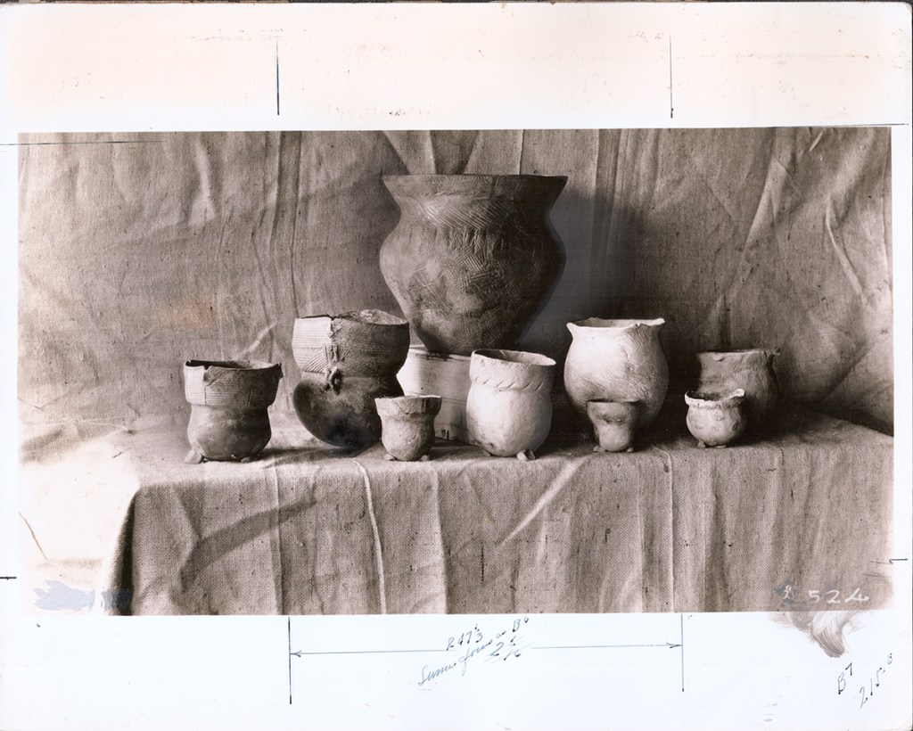
The third image, labeled #524, displays several pieces of Native American pottery with a difficult to read caption in cursive that might say, “Sumer focus as B6.” Let me know what you think the photo’s caption says.
Here’s a slideshow of the previously highlighted images. However, these images are uncropped with the back of the photo included where some additional notes can be found.


Special Thanks
Special thanks to Safe Harbor Water Power Corp. owned by Brookfield Renewable U.S. for allowing me access to their archives.
Never Miss a New Post
Never miss an Uncharted Lancaster blog post by signing up for email updates below and following Uncharted Lancaster on Facebook or Instagram.
Shop
Here’s your chance to purchase a beautiful reproduction map of Conestoga and Manor Townships from 1864 through 1899.
-
 1875 map of Manor Township, Lancaster County, PA$27.99
 -
 1875 map of Conestoga Township, Lancaster County, PAPrice range: $27.99 through $29.99
 -
 1894 Map of Millersville, Lancaster County, PennsylvaniaPrice range: $29.99 through $34.99
 -
 1899 Map of Manor Township, Lancaster County, PAPrice range: $29.99 through $34.99
 -
 1864 Map of Conestoga Township, Lancaster County, PAPrice range: $24.99 through $25.99
 -
 1899 Map of Conestoga Township, Lancaster County, PAPrice range: $29.99 through $34.99
 -
 1864 Map of Manor Township, Lancaster County, PAPrice range: $24.99 through $25.99
More discoveries from the Safe Harbor archives
The Lower Susquehanna before the dams. I have often wondered what the Lower Susquehanna looked like before the dams at Holtwood (1905) and Safe Harbor (1930) were built. Specifically, I was curious what the section of the river where the petroglyphs of Big Indian Rock and Little Indian Rock might have looked like to the Native Americans who carved them 1,000 years ago. Click here to read more.

Art: Occupation of Wrightsville by Lee’s Army, June 28, 1863. The curious document we uncovered was this print by Donald Ewin Cooke “from an authentic Civil War wood engraving” made by Albert Berghaus. Scroll down to read more about Cooke and Berghaus. I’m not sure how this print came to reside in the Safe Harbor archives, but it was a great find as neither Ben nor I had seen it before. Click here to read more.

Learn More
Artifact: ‘Indian Relics of the Lower Susquehanna Valley Preserved for the Public’ brochure

I was recently made aware of this rare vintage brochure from the 1950s entitled “Indian Relics of the Lower Susquehanna Valley Preserved for the Public.” Published by the Pennsylvania Water & Power Co., Safe Harbor Water Power Corporation, it has some fascinating information and photographs. As a firm believer that “information wants to be free,” I transcribed the document’s text and scanned the images. Both are available when you click the link.
Visiting Safe Harbor’s petroglyphs during a low water event. Click here to read about my voyage out to the Safe Harbor petroglyphs during a low water event.

Discover more from Uncharted Lancaster
Subscribe to get the latest posts sent to your email.
Same focus as B6? And this is picture B7. Other numbers could be camera settings??