Happy Birthday, Lancaster County!
On May 10, 1729, Lancaster County was erected after being carved out of a large portion of Chester County. Legend has it that beginning in 1728, residents living in the backwoods of Chester County began to complain that “thieves, vagabonds, and ill people” had infested the rural areas of what is now Lancaster County. They petitioned Governor Patrick Gordon for the creation of a new county to jettison these undesirable residents.
So nearly 300 years ago today Lancaster County was formed. It was the first county created beyond the original three counties of Bucks, Chester, and Philadelphia.

However, a more likely reason for the creation of Lancaster County was Chester’s size. At that time, Chester County’s borders were Philadelphia County to the north, the ill-defined western edge of the colony (approximately the Susquehanna River) to the west, the Delaware River to the east, and Delaware and Maryland to the south.

Residents, especially those near the western border of Chester, had to travel a great distance to reach the Courthouse in West Chester for legal matters like marriage licenses. That’s a long way to go via buckboard. The western edge of Chester County also needed its own jail for local criminals and people to maintain roads.

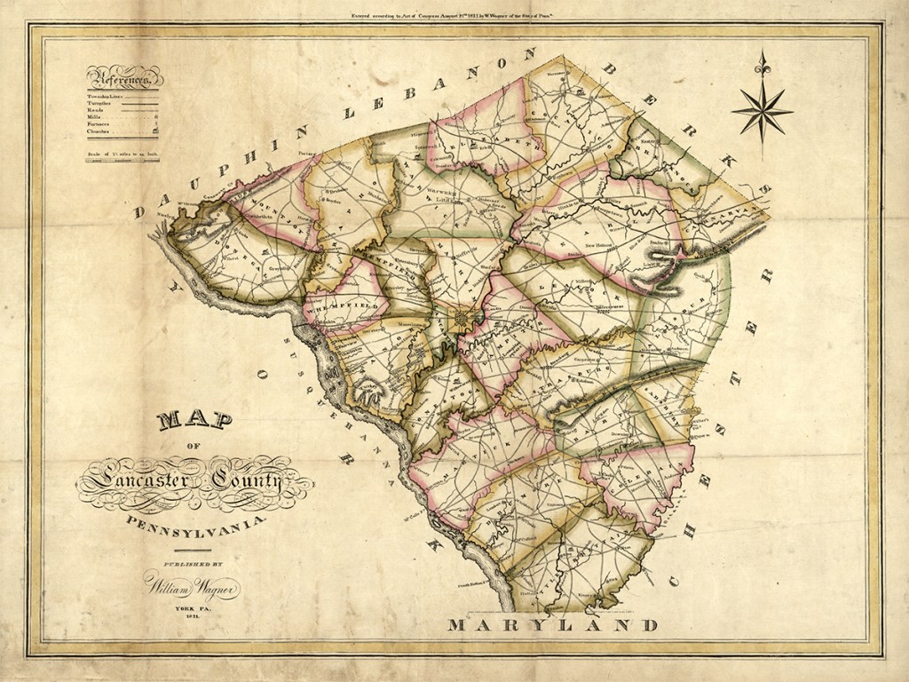
But you might be surprised to learn that Lancaster did not always have its iconic diamond shape. Its shape continued to evolve as neighboring counties were created in the 18th and 19th centuries. The following video by Tyler Huber takes a look at how the borders of Lancaster County were formed with York, Cumberland, Berks, and Chester counties.
Wagner’s map is historically significant. It is the first official document to show Lancaster County’s modern iconic shape.
Since its creation on May 10, 1729, Lancaster’s boundaries have changed several times over the decades, and it wasn’t until 1813 that it finally transformed into the diamond silhouette we recognize today. The first official map to show Lancaster County’s modern iconic shape was created in 1821 by prolific cartographer and engraver William Wagner. Click here to purchase a copy of this beautiful document.
A New Town is Born
The following year in 1730, Lancaster with its booming population of 15 was declared the county seat. However, at the time it was called “Hickory Town.” German immigrants, known as Pennsylvania Dutch, who had settled the region 20 years earlier in 1709 had given the Native American village there the name as a giant hickory tree stood in the town’s center. According to legend, the tree stood in the middle of what is now Penn Square.

In 1730, most of the land that would become the present-day City was owned by Andrew Hamilton. In 1733, he deeded 500 acres of this land to his son James Hamilton, who designed the layout of the new town using a uniform grid plan of straight streets and rectangular property lots in 1734. A town square—known initially as Centre Square and later called Penn Square—was placed in the middle of this town plan.
-
 1864 Map of the City of Lancaster, PennsylvaniaPrice range: $21.99 through $25.99
During Hamilton’s redesign, prominent citizen John Wright suggested the name Lancaster after Lancaster, England, where he used to live.
Hamilton sold lots to middle-class artisans, merchants, and professionals. Early residents were required to build within one year a substantial dwelling with dimensions of sixteen feet square at least, with a suitable brick or stone chimney. Innkeepers were known to acquire 15-20 acre lots for pasturing animals. By 1742 Lancaster was one of the largest inland towns in the British Empire, with 270 houses and 750 inhabitants. Lancaster is one of the oldest inland cities in the United States of America.

Lancaster was incorporated as a borough in 1742 and incorporated as a city in 1818.
In addition to being the county seat, Lancaster served as the state capital from 1799 to 1812 until Harrisburg replaced it. The city was even the nation’s capital for one day on September 27, 1777. The Continental Congress met in Lancaster as they fled British forces who had captured Philadelphia.

Adventure Awaits!
Never miss a new post or article by signing up below and following Uncharted Lancaster on Facebook or Instagram.
-
 William Wagner’s 1821 Map of Lancaster CountyPrice range: $24.99 through $44.99
Learn More
Then & Now: William Wagner’s 1830 Borough of York
In 1830, prolific cartographer, engraver, and artist William Wagner created a series of 38 watercolors that accurately showed how the Borough of York looked. In the pre-photography era, this remarkable collection of architectural views makes York, PA, one of the most highly depicted communities of the early nineteenth-century United States. I have attempted to match Wagner’s 1830 paintings with its modern Google Street Views counterpart. Today, those images can be found in the book, Views in the Borough of York & Vicinity. I have attempted to match several of Wagner’s 1830 paintings with their modern Google Street Views counterparts. Those Then & Now comparisons can be found below. Click here to read more and see all the images.


Resources:
- City of Lancaster History
- Lancaster History
- A History of Lancaster, PA
- Before Amish Quilts and Shoo-fly Pies
- Lancaster Townstead, 1901
- Andrew Hamilton
- James Hamilton
- Chester County, Pennsylvania
- John Wright (businessman)
Discover more from Uncharted Lancaster
Subscribe to get the latest posts sent to your email.
Thank you for this. In working on my ancestry, I was finding discrepancies over what was or was not in Lancaster County at various times. This explains the issues. Much appreciated.
Add to the complexity is Conestoga Township (in Lancaster County) predates Lancaster County and was much larger than it is today. Prior to 1729, it would have been part of Chester County.