Everyone has heard of a ghost town. But what about a phantom settlement? While they sound like synonyms, they have little in common. This summer, I visited examples of both. Read on to learn the difference and the tales of the ghost town of Billmeyer and the phantom settlement of Agloe. Spoiler Alert: Agloe has a truth is stranger than fiction story thanks to a curious mix of cartography, intellectual property, and geographical quirks.

Ghost Town
A ghost town refers to a once-thriving settlement or community primarily abandoned and left in decay. These towns typically experienced a decline in population and economic activity due to various reasons, such as changes in industry, resource depletion, natural disasters, or shifts in transportation routes. As a result, the buildings, infrastructure, and often the entire town are mainly left untouched, creating a haunting and eerie atmosphere. Ghost towns can be found worldwide and are usually of historical and cultural interest, attracting tourists and researchers who want to explore the remnants of these abandoned communities.
Billmeyer, PA
One of Lancaster County’s most famous ghost towns is the Village of Billmeyer, standing just downstream of the White Cliffs of Conoy.


In the 1840s, John Haldeman (of Haldeman Mansion fame) built two lime kilns in Conoy Township that annually produced 30,000 bushels of locally quarried lime. Click here to read about the benefits of lime and its production here in Lancaster County.
-
 1919 Road Map of Lancaster County PosterPrice range: $24.99 through $25.99
When John E. Baker assumed ownership of this quarry in 1894, he expanded its operation and recognized a need to establish a community for the men and women who labored there. As a result, the village of Billmeyer was founded on the riverside of the railroad tracks, and within it, people from diverse backgrounds were brought together by their shared labor. Billmeyer is likely named after Baker’s wife, Mary Billmeyer, or his brother-in-law and partner, George S. Billmeyer.


The village hosted its own general store, church, and school by fulfilling the basic needs of its community members. However, by the mid-1900s, as the quarry operations diminished, so too did the small village of Billmeyer, which its operation had sustained. Here is a brief video about Billmeyer.
Who doesn’t love a good ghost town, especially one accessible to the public? For this reason, I made Billmeyer the Week 1C stop in my 2022 $1,500 Easter Egg treasure hunting adventure. Here’s the poem telling participants where to go.
Opposite the ruins of lime fire
find the foundations of old Billmeyer.
A marker awaits southeast of white cliff
within sight of a black X hieroglyph.
Phantom Settlement
A phantom settlement (or paper town) is a term used to describe a fictional or imagined place that does not, in reality, actually exist. It can refer to a fabricated location, village, town, or city created for artistic, storytelling, or copyright trap purposes. They are often featured in literature, movies, video games, and other forms of creative media to serve as settings for narratives or to create a sense of atmosphere.
Cartographers use phantom settlements as copyright protection, serving as a type of watermark only the map maker knows of. Maps, like works of art, can be copied; therefore, map makers add a phantom settlement to their map for security. If they come across a map from a different source that includes the name of the phantom settlement they added, they have proof of copyright infringement. This addition to the map is meant to be subtle, designed to catch someone who would copy the map but not get someone using the document lost.
Agloe, NY
The most famous of all phantom settlements is Agloe, New York. It is a fascinating example of a fictional place that became real thanks to a curious mix of cartography, intellectual property, and geographical quirks.

The story of Agloe begins in 1909 with the creation of the General Drafting Corporation founded by Otto G. Lindberg. It was one of the “Big Three” road map publishers in the United States from 1930 to 1970, along with H.M. Gousha and Rand McNally. Unlike the other two, General Drafting did not sell its maps to various smaller customers but was the exclusive publisher of maps for Standard Oil of New Jersey, later Esso and Exxon. They also published maps for Standard Oil Company of Kentucky, a.k.a. KYSO. KYSO later merged with Standard Oil Company of California, better known as Chevron.
In 1923, Lindberg persuaded Standard Oil of New Jersey to let him draw the “best” road map of the state they had ever seen for free distribution. Standard was sufficiently impressed with the product to contract with General Drafting to make all their road maps—a relationship that lasted for six decades. The company’s cartography was regarded as “an outstandingly attractive road map design, unexcelled in the U.S.”
To protect this outstanding road map of New York, Otto G. Lindberg and an assistant, Ernest Alpers, assigned an anagram of their initials—Agloe—to a dirt-road intersection in the Catskill Mountains: NY 206 and Morton Hill Road, north of Roscoe, New York as a copyright trap against competitors.
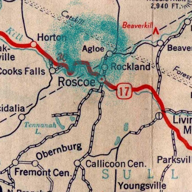
In the 1950s, the town of Agloe appeared on the map of a competitor, Rand McNally. Seemingly plagiarized, the General Drafting Co. threatened a lawsuit for copyright infringement. This is where things get weird. Rand McNally was innocent.
In the years since the paper town’s creation, people began using the name Agloe at the exact location where the cartographers had planted the fictitious town. As early as the 1930s, a nearby fishing lodge named Agloe opened. There’s even a postcard documenting its existence.

Then in the early 1950s, a general store was built at the intersection where Agloe wasn’t supposed to exist. The proprietor named it the Agloe General Store because the name was an Esso map he owned. He officially registered the business with the New York Delaware County Administration.
As it turned out, Rand McNally got the hamlet’s name for their map from the Delaware County administration. No copyright infringement had occurred since the fake town had become real. A strange example of life imitating art?
Eventually, the Agloe General Store went out of business because, let’s face it, there was never supposed to be a town there. Agloe eventually disappeared from paper roadmaps in the 1990s, but the Agloe General Store still appears on Google Maps (likely because the folks at Google have a sense of humor).
During one trip this summer, I found myself only 90 minutes away from the fabled New York town, so with my family in tow, we detoured to see the phantom settlement. It should come as no surprise that there’s nothing to see, but it was a beautiful drive that comes with some bragging rights. Here are a few of my photos of Agloe.

This non-descript intersection is the real-world location for the phantom settlement of Agloe, New York. The Agloe General Store was once located close to where the red building is in the background. 
This non-descript intersection is the real-world location for the phantom settlement of Agloe, New York. 
This non-descript intersection is the real-world location for the phantom settlement of Agloe, New York. This modern bridge replaced the covered bridge in the postcard above.
I am so fascinated with the idea of Agloe and its unique story that I included it on my 2023 $2,000 Jewel of the Susquehanna treasure hunting map. It was integral for figuring out the answer to the Week 1B riddle. Here’s the riddle.
In the north, a phantom settlement hides.
Travel down to where an alabaster town resides.
If you carefully examine Penn Township on my digitally edited version of the 1899 Road Map of Lancaster County (which served as that year’s treasure map), you will find the”phantom settlement” of Agloe. Just south of it is the “alabaster town” of White Oak.

Planning Your Trip
Billmeyer is located along the Northwest River Trail between Bainbridge and Riverfront Park, just downstream of the White Cliffs of Conoy. Here are the GPS coordinates: 40.071437, -76.651570. The closest parking area is Koser Park, located at 107 Race St, Bainbridge, PA 17502, approximately 1.6 miles away.
.
Park at Riverfront Park (551 Vinegar Ferry Rd, Marietta, PA 17547) to supersize this adventure as you approach Billmeyer from the south. While this is a longer trek of approximately 2.4 miles, it takes you beneath the beautiful Shocks Mills Bridge.

Agloe is located in the Catskill Mountains of Delaware County, New York, just north of Roscoe along Route 17. Here are the GPS coordinates: 41.965659, -74.906598. The modern street address for Agloe and the now defunct general store is 1 Morton Hill Rd, Colchester, NY 12776.
If you want to supersize your Agloe road trip, you can Dundas Castle, just three miles away. Own by the Temple Prince Hall Association, the massive castle is nestled along the Beaverkill River.
Fun Fact: While the name Beaverkill River has horror movie-sounding vibes, nothing could be further from the truth. “Kill” is the Dutch word for “little stream.” So in English, the name is literally Beaver Little Stream River. Sounds a bit redundant.

Dundas Castle. Image courtesy of Prince Temple Hall Associates. 
Dundas Castle. Image courtesy of Prince Temple Hall Associates. 
The gate at Dundas Castle. Image courtesy of Prince Temple Hall Associates. 
Dundas Castle. Image courtesy of Prince Temple Hall Associates. 
Dundas Castle. Image courtesy of Prince Temple Hall Associates. 
Dundas Castle. Image courtesy of Prince Temple Hall Associates.
Brief History of Dundas Castle
In the late 1880s, New York architect Bradford Gilbert acquired nearly 1,000 acres in the Catskill Mountains in what is now Roscoe, New York. On this property, Gilbert constructed his summer retreat, Beaverkill Lodge. Gilbert’s new wife, Maria, who was Irish, said, “The Catskill scenery reminded her of home.” She named the surrounding hamlet Craig–e–Clair, which translates as “beautiful mountainside.”
In 1903, the Gilberts sold the property to Morris Stembach. Four years later, Stembach sold it to Ralph Wurts-Dundas in 1907. Wurts-Dundas was a wealthy and prominent New Yorker and grandson of William Wurts, one of three brothers who built the Delaware & Hudson Canal. He eventually shortened his name to Dundas.
Dundas wanted to expand the existing Beaverkill Lodge into the finest mansion his money could buy. Construction photographs show Beaverkill Lodge being “encapsulated within the castle structure.” Dundas imported slate roofing from England, iron gates from France, and marble from Italy for floors, fireplaces, and staircases for his European-style castle. The only local product used was stone from the nearby Beaverkill River. The reception room’s fireplace was covered in gold leaf and valued at over $5,000 in 1910 ($160,890 in 2023).
Designed in Gothic and Elizabethan Revival styles, the 36-room residence was constructed between 1915 and 1924 but never completed or occupied by Dundas or his wife Josephine because he died in 1921. The castle was inherited by their daughter Muriel, along with some $40 million, but she did not go back to the Catskills and the castle.
In 1949, Muriel sold the property for $47,000 to the Prince Hall Grand Lodge of the Masonic Order. This Manhattan-based organization of African American Masons wanted to create “a Masonic home for the aged and indigent.” Unfortunately, that project did not happen, so the Masons developed the property into a vacation retreat, using a barn as a recreation center, an old farmhouse for administration, and the castle for a fishing and hunting resort. Over time, they added new structures and turned the property into a summer camp for inner-city youth. Named Camp Eureka, this is the main activity of the site today.
Unfortunately, you must limit your sightseeing from the road as the entire property is marked as no trespassing. Most of the estate is surrounded by thick vegetation, so time your Sunday drive for the winter for increased visibility. However, the beautiful wrought iron main gate imported from France sits along Beaverkill Valley Road and can be viewed from the comfort of your vehicle.

Dundas Castle is at 609 Craigie Clair Rd, Roscoe, NY 12776. The GPS coordinates for the impressive main gate are 41.963598, -74.866716. Note well: There was zero phone service on my visit to Agloe and Dundas Castle, so have both locations preloaded in your GPS before entering the area.
Adventure Awaits!
Never miss a new article by signing up for email updates below. Be sure to follow Uncharted Lancaster on Facebook or Instagram for exclusive content.
Resources
- RiverRoots: Forgotten Towns
- What is a phantom settlement and do they really exist?
- Seeking a Town on the Border of Fiction and Reality
- General Drafting
- Agloe, New York
- Dundas Castle (Roscoe, New York)
- Temple Prince Hall Association
Graveyard vs. Cemetery: What’s the difference?

Graveyard vs. Cemetery. What’s the difference? It’s subtle, but there is one. Click the link for the difference.

Discover more from Uncharted Lancaster
Subscribe to get the latest posts sent to your email.